SATELLITE IMAGE PROCESSING
ALOS
The size of DAICHI is 3.5m wide x 4.5m long x 6.5m high, with its Solar Battery Paddle is 22m x 3m wide, gross weight is approximately 4 tons, which is one of the largest among Land Observing Satellites.
120Mbps (Direct Transmission)
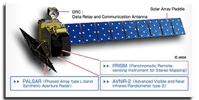
ALOS has three earth-observing sensors: Panchromatic Remote Sensing Instrument for Stereo Mapping (PRISM) for detecting elevations with high observing land coverage highly accurately, and Phased Array type L - band Synthetic Aperture Radar (PALSAR) for observing land areas day and night regardless of atmospheric weather conditions.
QuickBird
Is a high resolution satellite using a state-of-the-art BGIS 2000 sensor (PDF), QuickBird collects image data to 0.61m pixel resolution degree of detail. the satellite is an excellent source of high resolution environmental data useful for analysis of changes in land usage, agricultural and forest climates. QuickBirds imaging capabilities can be applied to various industries such as Oil and Gas Exploration & Production (E&P), Engineering and Construction and environmental studies
MS: 2.44 m (nadir) to 2.88 m (25 off-nadir)
TerraSAR-X
Is a German satellite designed to carry out its task for five years, independent of weather conditions and illumination, and reliably provides radar images with a resolution of up to 1m.
In the future, the PPP-funded TanDEM-X, a twin satellite to TerraSAR-X, will enhance the mission.
The satellite constellation will enable the generation of high-quality Digital Elevation Models (DEMs) on a global scale.

This image is taken using TerraSar-X satellite.
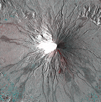
Mayon Volcano
also known as Mount Mayon, is an active stratovolcano in the province of Albay, in the Bicol Region, on the island of Luzon, in the Philippines.